The complete GIS platform, reimagined with AI at its core.
One platform to create interactive maps, manage spatial data, collect field information, and share insights — where AI works alongside your team at every step. Simple enough for beginners, powerful enough for GIS professionals.
Trusted by organizations in government, education, health, utilities and consulting







Start with the world's data — not an empty map.
Most platforms hand you a blank project. OrionGIS ships with a living, curated data foundation already loaded — boundaries, population, land cover, transport, climate, health — continuously updated, so your first question has something to run against on day one.
Curated from trusted national and international open-data programmes — cleaned, structured and continuously updated, with source and licence on every dataset.

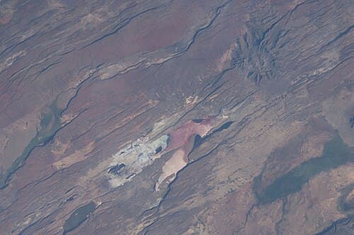




Spatial intelligence, built into the way you work.
One platform for the whole loop — built for GIS professionals, usable by everyone they work with.
Stop juggling between desktop GIS, web platforms, and mobile apps. OrionGIS connects your entire geospatial workflow in one ecosystem where everything syncs — and AI is native to every surface.
Work on maps simultaneously with teammates across continents — see changes in real-time, comment directly on features, and keep a complete version history of every edit. AI drafts, your team refines.
Transform raw geodata into polished, interactive web maps with a single click. Share with specific teams or the entire world — you control who sees what.
From field to dashboard in minutes.
OrionGIS streamlines every step of the geospatial workflow — with AI doing the heavy lifting at each one — so the loop from field to insight shrinks from weeks to minutes.
Your field teams collect data using our mobile app — photos, coordinates, custom attributes — even without internet connectivity. And AI drafts the form itself from a single sentence.
Data flows automatically to your central repository the moment connectivity returns. No manual uploads, no lost records.
See your data come alive on interactive maps. Apply symbology, create thematic layers, and generate insights instantly — or ask your data directly and get an answer you can trust.
Publish to stakeholders with granular access controls. Embed maps in reports or dashboards — or ask a dashboard a question and it answers with charts.
One platform. One continuous workflow.
Not a menu of tools — one workflow where every part understands the others, and AI carries the load in between. No assembly, no integration tax, no per-module invoices.
Enterprise-grade spatial database designed for scale — with a living catalogue of curated, versioned data ready on day one.
Drag-and-drop map builder with advanced cartography tools, custom basemaps, and dynamic styling.
Native Android field data collection with offline support and GPS integration — describe a survey in a sentence and AI generates the form.
Buffer, overlay, proximity analysis, and spatial statistics without writing a single line of code.
Schedule spatial processes and automate data pipelines — or let Orion AI do the work and verify the result before you act on it.
Live dashboards built on catalogue data — publish to stakeholders, or ask a dashboard a question and it answers with charts.
RESTful APIs, SDKs, and webhooks to embed mapping into your applications.
Ready-to-use basemaps, elevation data, satellite imagery and thematic layers — curated, cleaned and versioned with source and licence.
The AI is a force multiplier, not a replacement.
OrionGIS integrates seamlessly with the software your teams already know and trust — and your GIS professionals' judgement is what the AI's output gets checked against.



 MapInfoREST APIs
Direct QGIS plugin · OGC-compliant WMS/WFS/WCS · Compatible with all major GIS software · Export to GeoJSON, Shapefile, GeoPackage, KML
Start free. Pay in shillings as you grow.
Every plan includes maps, Map Studio, the catalogue and private uploads. Plans differ by OrionAI credits, storage, field submissions and seats. Pay by M-Pesa or card.
For trying it out, and for students
14 days of Team features to start
Start free- Maps, Map Studio, catalogue and private uploads
- 25 OrionAI credits a month
- 3 projects · 500 MB storage
- 250 form submissions a month · 2 forms
- 1 dashboard · 1 published map
For one consultant or researcher
about $15 a month
Get Pro- Everything in Free
- 200 OrionAI credits a month
- Unlimited projects · 5 GB storage
- 2,500 submissions a month · 10 forms
- 3 dashboards · 10 published maps
- Heavy processing · read API access
For a programme or small NGO
about $35 a month
Get Team- Everything in Pro
- 5 seats (+$5 each)
- 1,000 OrionAI credits a month, shared
- 20 GB storage · unlimited forms
- 10,000 submissions a month
- 20 dashboards · 50 published maps · 5 client accounts
For an NGO, firm or department
about $100 a month
Get Organisation- Everything in Team
- 20 seats (+$4 each)
- 3,000 OrionAI credits a month, shared
- 50 GB storage · 50,000 submissions a month
- Unlimited dashboards and published maps
- Read + write API · Google and Microsoft sign-in
For governments, counties, ministries and large programmes. Unlimited seats, agreed volumes, SAML sign-on, dedicated or on-premise deployment, SLA and training.
Prices in Kenyan shillings; US dollar figures are approximate. Registered nonprofits get 20% off. Limits are shared across an account's seats. Prices shown don't include applicable tax and may change. Need something else? Talk to us.
Know OrionGIS
Can we run OrionGIS on our own infrastructure?
Yes — three ways. OrionGIS Cloud is fully managed by us (updates, backups, scaling, security). On-premise runs entirely on your own servers for complete data sovereignty — ideal for government and compliance-bound organizations. Hybrid keeps sensitive data local while public-facing maps scale in the cloud.
What does the free plan include?
The full platform — interactive maps, spatial analysis, the curated data catalogue and native dataset upload — plus AI answers capped at 10 questions a month. Paid plans add forms, dashboards, and fuller AI limits.
Does the AI replace our GIS team?
No. The AI is a force multiplier: it drafts forms, runs analyses and builds dashboards so specialists stop doing busywork. Every result is verified before it publishes, and your GIS professionals' judgement is the standard it's checked against.
Can I keep using QGIS or ArcGIS?
Yes. Every dataset is exposed as standard OGC WMS/WFS, so it drops straight into any GIS desktop client you already use — plus a direct QGIS plugin and exports to GeoJSON, Shapefile, GeoPackage and KML.
Do I need to install anything?
No. The catalogue, map viewer, projects, and field-form management all run entirely in your browser.
Where is my data hosted?
On infrastructure you control. OrionGIS runs on your own servers or cloud instance — your data never sits on a third-party platform you don't own.
What happens to data collected in the field?
OrionForms submissions show up inside OrionGIS as soon as they sync, ready to export to CSV or GeoJSON.
Can I get my data out if I ever need to?
Any time. Every dataset can be downloaded in its original format — there's no proprietary lock-in, by design.
Ready to transform your spatial workflows?
Launch your first project in minutes. No credit card required — or talk to us about a team rollout, an enterprise deployment, or running OrionGIS on your own infrastructure.